Route statistics
Starting point
Brod Moravice
Length
17 km
Total ascent
511 m
Highest point
688 m
Lowest point
381 m
Physical difficulty
3/5
Technical difficulty
2/5
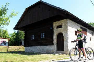
We head uphill to the village of Gornji Kuti, the cultural centre of the Brod Moravice area. Then we ride downhill through Maklen and Moravička Sela, and after Klepeće Selo turn left towards Podgorani. You will be cheerfully greeted by the few inhabitants of these poorly-populated villages, and the wonderful aroma of freshly baked apple pie coming from their kitchen windows. Today, these villages represent valuable folk architecture and ethno zones. The trail then descends through Kocijana to the main road coming from Brod na Kupi, and then an asphalt road takes you back to Brod Moravice.
In the Brod Moravice area, there are as many as 12 sacral buildings, while the oldest one, the church of St. Nicholas in Brod Moravice bears the inscription on the door which indicates the year 1431 as the year of construction. Beside the church there is the Turanj Tower, which was built by Prince Zrinski in the 16th century as a defence against the Turks.